Whether it is collecting, reading, drawing, or painting, maps have always been one of my greatest passions. Therefore, it should come as no surprise that I consider maps an essential tool in my genealogical research. As a researcher, even if I know that some of my ancestors spent their entire lives in the same city or town, I can never assume that they always lived in the same exact location. There are a multitude of sources where an individual’s address at any given point can be found, including:
- City Directories
- Census Records
- Draft Cards
- Birth and Death Records
- Newspapers
City and Town Directories
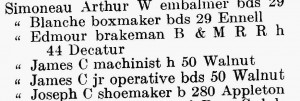
When it comes to mapping locations within a city or town, directories can be among the most helpful resources. While city directories have been around since the eighteenth century, they started appearing in most cities and towns by the late nineteenth century. In essence, they can be considered a phone book before most people owned telephones. Typically, city directories were published on a yearly basis, and therefore allow genealogists to determine where within a city an individual lived during that year. Above is an example from the 1910 Lowell city directory.
In this example, the individual’s occupation is listed, followed either by ‘bds,’ which is short for ‘boards,’ or ‘h,’ which stood for ‘house.’ City directories are also helpful as they often list the date of death of an individual who died after the directory was published the previous year or indicate that a person removed to another town.
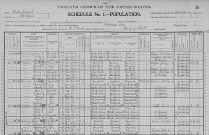
Most genealogical researchers are well aware of the importance of census records both at the national and the state level. While many use the records to show that an individual was in a certain town at a particular time, these records also often list the exact address of the family being surveyed, allowing us to know precisely where in a town the family was residing, the importance of which will be discussed in Part 2.
Draft Cards
Even if an individual did not serve in the military, if they were residing in the United States during one of the major wars of the twentieth century there is a good chance that they were required to fill out a draft card which can be used to find not only a person’s exact date of birth, but also his/her address as well as the address of their nearest relative.
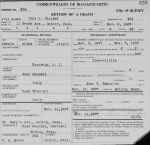
In both Rhode Island and Massachusetts (among many other states) in the twentieth century, parents who filed a birth record were asked to give their current address at the time of the child’s birth, which allows modern researchers to determine where the parents were living. The same applied to death records, as the address of the deceased individual as well as an informant was required for the documentation. Many of these documents prior to World War II are readily available to researchers.
Newspapers
Newspaper articles, including marriage and death announcements, are also an easy way to determine where individuals were living at a given time, as they often gave the individuals name followed by ‘of [local address].’
Concluded here.


Maps – Absolutely useful. A Kansas County township map of 1902 with names on the sections helped me sort out ownership for men who acquired land via Civil War service in 1872 as well as purchased from the Federal government. Adjacent property owners names were also very useful, some of them being relatives. I love maps!
Maps are a great way to make connections between people as well. You can see who lived within walking distance of each other and if there were railroad or trolley lines near their residences that would have made it easy to travel back and forth with each other. Two of my favorite resources for old maps are the Leventhal Map Center which has a wide variety of maps from around the world and back into some of the earliest maps in existence: http://maps.bpl.org; and the USGS service that allows you to go to a location and see how the location has changed over time by switching from one map to another: http://historicalmaps.arcgis.com/usgs/. If you use the levers to make maps more transparent, you can actually see the development of streets over time.
In addition to the resources you mentioned, the states of Massachusetts and New Hampshire have their land records available online. You will need to know which county your ancestor lived in but then can search for your ancestor by last name. This lead to my finding another line to research since my great-great-grandfather bought land from his father-in-law and in researching this, I found that so had his brother-in-law and sister-in-law. The Massachusetts records are at http://www.masslandrecords.com and New Hampshire’s records may be found at http://www.nhdeeds.com. I am sure many other states have at least some of their records available online.
Away from the original 13states there are plat maps that show who filed on what property. Moving westward one can capture ancestors who might not hit other sources. In Arkansas I found the connection among three families and the two marriages of one young girl. Names and dates were in census, etc. but not the why.
Diana’s information is fascinating. I can’t wait to go explore it. Another map resource I’ve used in the past were platt maps for early townships. They were excellent for seeing how and where families lived. Especially knowing where future generations would intermarry. One interesting find I made, was a surprising coincidence. My husband’s family migrated to Texas in the early 19th century, but has ties to New England going back to the 17th century. My family is from NY and CT. While examining a platt map for my own family research, I discovered my husband’s family lived next door to my family about 300 years ago in CT. Amazing!
SABE EU AINDA BUSCO POR INFORMAÇÃO E FOI MUITO BOM VER ISTO PORQUE BUSCO VER O QUE ACONTECEU COM MEUS ANCESTRAIS , PORQUE TANTAS TROCAS DE SOBRENOME, SOU UM CARLONI,EM BRASIL
I agree about the importance of maps. I hope you will tell us what tools you use to analyze locations and to produce maps for printing and for web presentations. It would be good to have an interactive tool that would allow the user to plot the locations and movements of a person or set of people.
The genealogy program I use has that ability, and one can enhance it with specialized 3rd party add-ons. I think there are several programs with that capability. Mine at least is not expensive.
What program do you use?
Does anyone know if there is a way to find the actual street address from census information, if the census only listed the district and the # in which residences were visited? (Why not just use addresses?).
depending on the census year, if you look at the column to the very far left, usually, the street name is written vertically. Then, each household is given a number. Here is an example from the 1930 Census:
https://pastprologue.files.wordpress.com/2010/04/kelly-1930-census-clip1.jpg
The Kelly family lived at 7514 Russington Street.
I use Zachary’s hint all the time, and add the address to the Location field on FTM, PAF, etc. But some years don’t give the address. I was once able to locate the house by using an old plat map with resident’s names written in. Followed the census-taker as he walked up the street, matching those names which appeared on both the census and map (different years) and pinpointed my ancestor’s home that way. A little tedious, but the discovery made up for it !