Tracing the origins of Canadian ancestors can be difficult, and the lack of early vital records can prove frustrating. Often, we have to turn to other sources to help piece together family histories. One of the “other sources” that I love to use are maps. Maps not only provide us with the locations of our ancestors’ homes or farms, they can also provide us with significant clues. Here are just a few sources that I have come across that I hope will aid you in your Canadian research.
Nova Scotia
Crown Land Grant Maps
The Crown Land Information Management Centre at the Nova Scotia Department of Natural Resources maintains Index Sheet Maps of Nova Scotia Crown Land Grant maps. If you know the general vicinity of where your ancestor settled, then the Index Sheet Maps will prove useful. Here, you can click on each quadrant, and search for your ancestor’s name. I find maps like these useful because you can see who lived near your ancestor. Once you locate the land grant, you can email thensdnrlib@gov.ns.ca or call 902-424-8633 to order a copy of the corresponding documents.
William McKay’s “The Great Map”
In 1834, William McKay completed the first comprehensive map of Nova Scotia. Some of these maps include the names of residents. These large scale maps are available at the Provincial Archives of Nova Scotia.
The A.F. Church maps
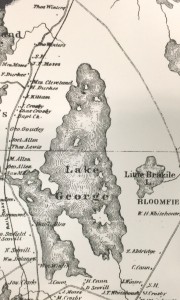
Cartographer Ambrose Finson Church created these detail-rich maps in the nineteenth century. Beginning with Halifax County in 1865, A.F. Church completed a map for each county until the completion of Queens County in 1888. These maps contain township information as well as heads of household, businesses, and prominent residents. I was able to locate some of my own ancestors near Lake George, just outside of Ohio in Yarmouth County. Here at NEHGS, we have these maps in our Technical Services Map Case.
Historical Maps of Nova Scotia
The Provincial Archives of Nova Scotia maintains a wonderful collection of maps. Many have been digitized, and you can search for them here.
New Brunswick
The Provincial Archives of New Brunswick has digitized and made available Cadastral Maps. On the Provincial Archives of New Brunswick website, these cumulative maps are organized by community within the Where is Home? section. These maps show the grantee of each Crown Land Grant.
Prince Edward Island
Another map that I really enjoy using is the 1863 Lake Map. Produced by civil engineer D. Jackson Lake, this map includes data from the 1861 Census of Canada, and you can view sections of this map by lot. Islandregister.com has digitized these maps, and we also have the 1863 Lake Map here at NEHGS. If you have Prince Edward Island ancestry, this map is a must!
Some absolutely fabulous resources here; thanks so very much! The detailed maps are a true treasure trove.
Thank you Sheilagh. What a terrific suggestion and resource list. Just found the land of several ancestors on maps posted on the Provincial Archives of New Brunswick site. Can’t wait to explore the Nova Scotia links.
Thanks for this. Waiting patiently for an opportunity to visit the Archives up there.
Quick question: What would be defined as “Halifax-Hants Boundary” as described in the “Situation” column of the “Loyalists and Land Settlement in Nova Scotia” book?
And for clarification, this would be in 1784, since I know the years are very important when talking Nova Scotia county borders.
Do you have any for Quebec or Ontario
I ” second” that request…
Ryan- Sure sounds like the boundary between Halifax and Hampshire counties if there are those counties in N.S.. “Hants” in England is short for Hampshire. And thanks for the article, Sheilagh. Property locations can answer many questions and I use them when I can find them.
Nova Scotia only has Hants county – no Hampshire county.
I am not sure I can find “The Great Map” by William Mckay that is referenced about, using that link. Is there something specific to search for once on that site? Thanks
It sounds as if this archive is only maintains records of the English settlers, yes? Nothing there (maps or documents) about the French settlers who were expelled by the British in the 1760s?
From what I know of the maps of Crown Grants in NS and NB is this: they identify the land grants made to settlers beginning with the first English efforts to establish the English presence here and displace or prevent the French from expanding they’re presence. I think that these Crown Grant maps probably capture grants dating from about 1749 (the founding of Halifax) and onwards.
Not having any French family connections, I do not know if any maps exist of French settlers who arrived in these provinces starting somewhere around 1600. I believe the University of Moncton (Universite de Moncton?) is the “go to” place for anyone doing research on French families in the Maritime Provinces.
Thanks so much for this thorough & thoughtful reply.